Adventures at home, abroad, and online

Category: Mapping Palestine Page 3 of 4

Research trip to the West Bank

Sacred Sights

Hannah slept like a rock last night. After a leisurely morning, we went to the Old City so she can get her bearings. Wandered around in the Muslim Quarter for awhile, then moseyed over to the Wailing Wall. Hannah was constrained to the women’s area, but I wandered into the air conditioned synagogue in the tunnels to the left. Fundamentally unfair, but I guess that’s the way it is. Then we ascended the Temple Mount/Haram al-Sharif via the Maghrebi-gate. I thought the whole complex was closed to non-Muslims, but we didn’t have any trouble. It’s a profoundly beautiful spot, as the pictures attest. Sadly, I think that if “we” got to rebuild the temple it wouldn’t be nearly as pretty.

Hipster shades
Practicing her Arabic
Us and the Dome
Hannah above the Wall


Met Nitin and the Voices Beyond Walls crew for drinks, so Hannah could meet them. Then we met Hannah’s friends Carrie and Brian for waffles and a walk through the German Colony. She’ll hang out with them on Shabbat, and Jared and I will go on an adventure. More on that later.

Hebron

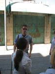
Went on a tour with the observers from the Temporary International Presence in Hebron. Rosa managed to get us in, as she used to work for the Danish Representative Office in Ramallah, and the observers are mostly Scandinavian. How very diplomatic of them…
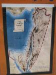
"Greater Israel"

The TIPH was created in 1997 as an addendum to the Oslo Process, and so has been temporary for over twelve years, with no sign of it ceasing to be necessary. Hebron is perhaps the mostly starkly divided city in the West Bank, home to 150,000 Palestinians and 530 settlers. The modern settlement was founded by Moshe Levinger and his wife Miriam; to whom I don’t think I am directly related, but which nonetheless colored my experience.The settlers are explicitly ideological, and espouse the goal of establishing “Eretz Israel” from the Nile to the Euphrates, with violence as an acceptable means. They occupy an area in the heart of the old city, near the Abraham Mosque/Cave of the Patriarchs. Violence has gone both ways, with a massacre of 67 Jews in 1929, the killing of six yeshiva students in 1980, and ongoing violence by settlers against the local community. In December 2008, after being forcibly removed from Beit Hashalom, a building they claim to have legally purchased despite the disagreement of the Israeli high court, settlers went on a rampage of Palestinian shops, shooting one man.
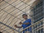
Settler Kid
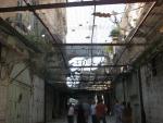
Screen to protect Souq from Settlers

To me, the more insidious violence is the everyday interaction, not the massacres. The old city souq is covered with protective wire to shield the Palestinian shoppers from thrown stones and bottles, although it cannot stop dirty water or urine. As I was walking through taking pictures, a young boy spit at me from several stories up, missing by inches. His aim indicated significant practice.

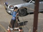
Settler girl with big gun
Jewish Star on Palestinian shops

Palestinians are forbidden from using several streets by the settlements, separating children from a school. TIPH observers walk every morning with them for protection. On this road, I saw a young woman nonchalantly carrying a very large automatic weapon. When I asked our guide whether a permit was required for such a gun, she replied “I’ll bet she knows how to use it.” The graffiti covering Palestinian shops and schools shows a new use of the Star of David. From its use to identify Jews in the Holocaust, it is now for these people a symbol of nationalism, and a marking of a different kind.

I had been to Hebron before with Jared and Jenna last summer, and we walked around the settlement area some. But being there with the international observers and hearing their assessment was a whole different experience. The souq was nearly empty, perhaps because it was a Friday, but it lacked much of the vibrancy I remember last year. We did avoid having any weapons pointed directly at us, as we had in the Freedom Cafe last summer. That much was a relief. I can’t imagine living in that tense of a situation, as a settler, Palestinian, or international observer. Just being there for a few hours was enough, and left me with lots to think through.

A Day of Cultural Discontinuities

I met a friend of a friend from the internet today to do some cross-border mapping. We started in the Old City, where she hadn’t seen, getting suitably caffeinated for the walk to come. I took her to Shufat camp, as it’s not currently well mapped in the OSM dataset, and it’s a profoundly different place than Jerusalem, despite being less than 10 miles away. The change from Jewish West Jerusalem to Arab East, and then to the camp itself, is really striking. Language, religion, politics, and government services all shift over a short distance. We talked about the discontinuity as we walked around gathering road and point data.

Ein Kerem Panorama

Then we did a total turn around, and went to the “artists colony” at Ein Kerem. The tranquility of the lush valley hides an ugly past. It was an arab village that was “abandoned” in 1948, or so a resident said, making sure to point out that there wasn’t a massacre here as there was at Deir Yassin only a few miles north. But whether or not there was physical violence, people did not leave these beautiful houses without reason. The very reason the town has so much charm, and is now becoming trendy, is due to the vanished occupants. Those same families now live in places like Shufat, so far from their old homes.

Temple Mount
Herodian column

After that jarring experience, we decided to go for the full Zionist kick at the Western Wall tunnels. She had another friend who met us there, and we were wowed by the multimedia-archaeological spectacle. The tour guide expounded on the glory of King Herod’s engineering feat: leveling the top of Mt Moriah, the center of creation and the spot where Abraham prepared his son for sacrifice, and building upon it a glorious temple. The tunnel follows the western retaining wall of the temple mount, which is far longer than the small “wailing” section reveals. There are some massive stones down there, bigger than those used in the pyramids. Although, it was built 2000 years after Giza with Roman techniques, so let’s not get too excited.

Damascus Gate
Qalandia backup

I bid my new friend adieu as she went to the airport, and I headed back to Ramallah. There was a long wait at the checkpoint while the rush hour traffic cleared. There’s no actual check going out of Israel proper into the West Bank, but there was a backup nonetheless. Went out for drinks with other internationals, and discussed the relative dependence of Palestine on NGO funding over many rounds of Taybeh beer. The taste of the revolution, indeed.

Maps!

Nadya asked for map updates, so here we go. I made these two while doing the spatial exercise with the kids, and to test out my GPS-photo geocoding workflow. KML files are attached, for your viewing pleasure.


Jerusalem Shufat

I’ve also been working on the GroundTruth test platform, and fixed several outstanding bugs related to the routing. Of course, now I think I will abandon Mapfish and go back to Django, but it was a good learning experience. Mapfish is just too finicky, and while it’s clearly powerful underneath, I can do everything I need with Django, and get a nice interface for free. Now I just need to convince local NGOs to buy in and share their data, so this tool is actually useful. More on that later.

In Ramallah

Got to Ramallah after 20 hours and 7 modes of transportation. It’s a busy town, but not quite as chaotic as I had expected. The traffic lights are respected, there is trash pickup, and there are internationals seemingly everywhere.

The lodging is great, sharing with a bunch of very friendly and helpful folks. We had excellent Indian food for the first night, and for several days of leftovers since. Spent the first day recovering from jetlag and walking around the neighborhood, and the last two volunteering with Nitin’s project, Voices Beyond Walls. It’s a two week camp where kids from Jerusalem and Shufat camp learn to make short films. We did a small mapping exercise to start, asking the kids to show us their neighborhoods and the places that make them unique. They had a surprisingly good spatial sense, and made pretty good maps.

Kids in the Hammam
Our tour guides
Anne getting them to explore the scene


Shufat kid enjoying popsicle
Tired at the end of the day


Setting up meetings for later in the week with NGOs. I finished the upload of the west bank to OpenStreetMap, and now it’s merged it with the Israeli one. If only integration in the real world were so easy…

Dome of the Rock
The Wall at Qalandia
Wall between Shufat and Jerusalem

Page 3 of 4

Powered by WordPress & Theme by Anders Norén